


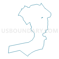
Voting District 2400042, Queens County, New York
About
Outline

Summary
| Unique Area Identifier | 635279 |
| Name | Voting District 2400042 |
| County | Queens County |
| State | New York |
| Area (square miles) | 0.07 |
| Land Area (square miles) | 0.07 |
| Water Area (square miles) | 0.00 |
| % of Land Area | 100.00 |
| % of Water Area | 0.00 |
| Latitude of the Internal Point | 40.72422490 |
| Longtitude of the Internal Point | -73.77167970 |
Maps

Graphs
Select a template below for downloading or customizing gragh for Voting District 2400042, Queens County, New York


Neighbors
Neighoring Voting District (by Name) Neighboring Voting District on the Map
- Voting District 2400041, Queens County, NY
- Voting District 2400043 2400044, Queens County, NY
- Voting District 2400046, Queens County, NY
- Voting District 2400085, Queens County, NY
- Voting District 2400087, Queens County, NY
- Voting District 2400088, Queens County, NY
- Voting District 2400103, Queens County, NY
Top 10 Neighboring County Subdivision (by Population) Neighboring County Subdivision on the Map
Top 10 Neighboring Place (by Population) Neighboring Place on the Map
Top 10 Neighboring Unified School District (by Population) Neighboring Unified School District on the Map
Top 10 Neighboring State Legislative District Lower Chamber (by Population) Neighboring State Legislative District Lower Chamber on the Map
Top 10 Neighboring State Legislative District Upper Chamber (by Population) Neighboring State Legislative District Upper Chamber on the Map
Top 10 Neighboring 111th Congressional District (by Population) Neighboring 111th Congressional District on the Map
Top 10 Neighboring Census Tract (by Population) Neighboring Census Tract on the Map
- Census Tract 492, Queens County, NY (4,750)
- Census Tract 472, Queens County, NY (3,760)
- Census Tract 1277, Queens County, NY (3,633)
- Census Tract 476, Queens County, NY (1,326)
- Census Tract 1283, Queens County, NY (73)